Over the past several years I have been discovering and snapping photos of historic stone milemarkers in Burlington County. The quest began in my hometown of Vincentown, where on the corner of Red Lion Road and Mill St., near my home, I would daily pass the marker shown here:
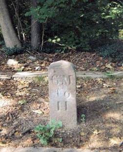
Vincentown Mile Marker: 6 miles to Hainesport
I wondered if there were others in the county. The second one I discovered was at the top of Mt. Laurel Road at East Main St. in Moorestown. Gradually I accumulated photos of 8 markers, none of them more than about 3 miles apart in a contiguous route, extending for 16 miles from Vincentown to the border of Camden County in Maple Shade. After incorporating the images into my "Burlington County Trivia" lecture, several people have shared information about 3 other markers they have discovered, and I have recently added them to the presentation. I have updated the short slide show and gathered them here in a Power Point presentation which can be accessed below:
Power Point Presentation of 11 stone Mile Markers in Burlington County
The project is a work in progress, as I continue to search for additional markers and attempt to identify the approximate period in which they were installed ( most of them between 1848 and 1860). At a recent lecture I was told that there was one in Gloucester County in the town of National Park, which leads me to believe that some may be associated in some way with the old Salem Road. Anyone with information on these stone markers should contact me.
Joe Laufer |